

Pixel3K
-
Posts
45 -
Joined
-
Last visited
-
Days Won
6
Reputation Activity
-

 Pixel3K got a reaction from Ionia in [Factbook] The Directorial Republic of Rivalfiume
The Directorial Republic of Rivalfiume
Repùbblika Direttoriale Fluvjana
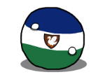
State flag and Civil ensign
Coat of Arms
Naval ensign (left) and naval jack (right)
Maps of Rivalfiume [WIP]
Location of Rivalfiume (red) in Southern Nur.
Fluvian Departments (First level of territorial subdivision)
[WIP]
Fluvian Departments + their departmental capitals and other important cities
[WIP]
Fluvian Provinces (Second Level of territorial subdivision)
Legend of the Fluvian Provinces:
Fluvian Districts (Third level of territorial subdivision)
Political Map of Rivalfiume (Departments, Provinces, Districts)
Official Language(s): Fluvian, Karačese (recognized minority language spoken in the Island of Karačo)
Example of Fluvian
WIP
Example of Karačese
WIP
Common Translation
Every man born and residing in the territory of the republic, who has reached the age of twenty, and has had himself registered in the civic register of his municipality, provided he is not a beggar or a vagabond, is an active citizen of the Republic.
(Extract of the Old Fluvian Constitution, Art. 7)
Other Language(s): Common
Demonym(s): Fluvjano/Fluvjani (Fluvian/Fluvians)
Capital City/Largest City: Grankastello
Government Type: Directorial Republic
Head of State/Head of Government: The Grand Directory
Land Area: 153'213 km2/59'156 sq mi
Population: 4'105'420 (1422 Estimate)
Population Density: 26.8 Inhabitants/km2, 69.4 Inhabitants/sq mi (1422 Estimate)
Continent: Nur
Borders (Updated 1422): Sekiya (North), Ionia (East, South), Great Pacific Ocean (West)
Time Zone: +5 IAT
Currency: Fiorino Fluviano (Fluvian Florin) (ƒƒ)
GDP (PPP): $147'700'698'592 (ƒƒ 177'240'838'311)
Per Capita: $35'977 (ƒƒ 43'173)
Drives on: the left
Calling Code: +5 40
TLD: .rf
The Directorial Republic of Rivalfiume (Fluvian: Repùbblika Direttoriale Fluvjana), also known colloquially as the Republic of Rivalfiume, the Fluvian Republic (Fluvian: Repùbblika Fluvjana) or simply Rivalfiume (Fluvian: Rivalfjume, pronounced ree-val-few-may), is a small, mountainous country located in southern Nur. Its name directly translates to "By the river". As of 1424, Rivalfiume is the only directorial republic in all of Esferos and one of the smallest and least populated countries in Nur. Its capital city and largest city, Grankastello (1423 Census: 411'763 inhabitants), was built on the coastal regions of Rivalfiume, where the terrain is lower and more fertile. Most of Rivalfiume's cities are found on the coast or alongside rivers. The country is divided in 9 Departments (Fluvian: Dipartimenti), and departments are further divided into provinces and districts.
Rivalfiume's economy is very diversified, mainly lead by fishing, tourism, agriculture, raw materials (wood, high-quality wool, iron, aluminum, zinc, building stones such as granite, sandstone, limestone and, to a lesser extent, marble) and derivates (steel panels, either exported as is or transformed in many other products, stone slabs/polished stone used for construction, insulation panels, wooden furniture and tools, wood pulp, paper).
Departments of Rivalfiume
Rivalfiume's Departments are the first levels of territorial subdivision of the country. Departments are divided further into Provinces, and Provinces are also divided in Districts.
Below is a list of Departments. [WIP]
Flag Department Name Population Area Pop. Density Dipartmental Capital Bajamajore 988'900 18591.4 km2 53.2 people/km2 Bajamaǧore Barsè 281'060 19077.4 km 14.7 people/km2 Barsè Basamja 315'770 3308.9 km2 95.4 people/km2 Porto Reubo Estre Nort 125'980 19103.3 km2 6.6 people/km2 Altipì Momponevre 92'000 33880.1 km2** 2.7 people/km2 Momponevre Grankastello 1'215'200 7224 km2 168.2 people/km2 Grankastello Lungoǧesi Alto 454'220 24295.1 km2 18.7 people/km2 Vanone Lungoǧesi Baso 529'100 21124.9 km2 25.0 people/km2 Porto Marko Vajo 103'190 6607.5 km2 15.6 people/km2 Vajo
**Including the area of the Island of Karačo (991.6 km2)
-
 Pixel3K reacted to Sekiya in [Factbook] Republic of Sekiya
Sitemap
Overview Country Divisions Federal Republics Federal Territories Autonomous Republics States & Administrative Regions Politics & Diplomacy Internal Affairs Foreign Affairs Culture Culture & Languages Sports Mythology & Religion Timeline Geography, Natural Features & Fauna Notable Cities Economy Companies list Economic Sectors Republican Military Organisation Supply & Ordnance
-
 Pixel3K got a reaction from Nox in [Factbook] The Directorial Republic of Rivalfiume
The Directorial Republic of Rivalfiume
Repùbblika Direttoriale Fluvjana
State flag and Civil ensign
Coat of Arms
Naval ensign (left) and naval jack (right)
Maps of Rivalfiume [WIP]
Location of Rivalfiume (red) in Southern Nur.
Fluvian Departments (First level of territorial subdivision)
[WIP]
Fluvian Departments + their departmental capitals and other important cities
[WIP]
Fluvian Provinces (Second Level of territorial subdivision)
Legend of the Fluvian Provinces:
Fluvian Districts (Third level of territorial subdivision)
Political Map of Rivalfiume (Departments, Provinces, Districts)
Official Language(s): Fluvian, Karačese (recognized minority language spoken in the Island of Karačo)
Example of Fluvian
WIP
Example of Karačese
WIP
Common Translation
Every man born and residing in the territory of the republic, who has reached the age of twenty, and has had himself registered in the civic register of his municipality, provided he is not a beggar or a vagabond, is an active citizen of the Republic.
(Extract of the Old Fluvian Constitution, Art. 7)
Other Language(s): Common
Demonym(s): Fluvjano/Fluvjani (Fluvian/Fluvians)
Capital City/Largest City: Grankastello
Government Type: Directorial Republic
Head of State/Head of Government: The Grand Directory
Land Area: 153'213 km2/59'156 sq mi
Population: 4'105'420 (1422 Estimate)
Population Density: 26.8 Inhabitants/km2, 69.4 Inhabitants/sq mi (1422 Estimate)
Continent: Nur
Borders (Updated 1422): Sekiya (North), Ionia (East, South), Great Pacific Ocean (West)
Time Zone: +5 IAT
Currency: Fiorino Fluviano (Fluvian Florin) (ƒƒ)
GDP (PPP): $147'700'698'592 (ƒƒ 177'240'838'311)
Per Capita: $35'977 (ƒƒ 43'173)
Drives on: the left
Calling Code: +5 40
TLD: .rf
The Directorial Republic of Rivalfiume (Fluvian: Repùbblika Direttoriale Fluvjana), also known colloquially as the Republic of Rivalfiume, the Fluvian Republic (Fluvian: Repùbblika Fluvjana) or simply Rivalfiume (Fluvian: Rivalfjume, pronounced ree-val-few-may), is a small, mountainous country located in southern Nur. Its name directly translates to "By the river". As of 1424, Rivalfiume is the only directorial republic in all of Esferos and one of the smallest and least populated countries in Nur. Its capital city and largest city, Grankastello (1423 Census: 411'763 inhabitants), was built on the coastal regions of Rivalfiume, where the terrain is lower and more fertile. Most of Rivalfiume's cities are found on the coast or alongside rivers. The country is divided in 9 Departments (Fluvian: Dipartimenti), and departments are further divided into provinces and districts.
Rivalfiume's economy is very diversified, mainly lead by fishing, tourism, agriculture, raw materials (wood, high-quality wool, iron, aluminum, zinc, building stones such as granite, sandstone, limestone and, to a lesser extent, marble) and derivates (steel panels, either exported as is or transformed in many other products, stone slabs/polished stone used for construction, insulation panels, wooden furniture and tools, wood pulp, paper).
Departments of Rivalfiume
Rivalfiume's Departments are the first levels of territorial subdivision of the country. Departments are divided further into Provinces, and Provinces are also divided in Districts.
Below is a list of Departments. [WIP]
Flag Department Name Population Area Pop. Density Dipartmental Capital Bajamajore 988'900 18591.4 km2 53.2 people/km2 Bajamaǧore Barsè 281'060 19077.4 km 14.7 people/km2 Barsè Basamja 315'770 3308.9 km2 95.4 people/km2 Porto Reubo Estre Nort 125'980 19103.3 km2 6.6 people/km2 Altipì Momponevre 92'000 33880.1 km2** 2.7 people/km2 Momponevre Grankastello 1'215'200 7224 km2 168.2 people/km2 Grankastello Lungoǧesi Alto 454'220 24295.1 km2 18.7 people/km2 Vanone Lungoǧesi Baso 529'100 21124.9 km2 25.0 people/km2 Porto Marko Vajo 103'190 6607.5 km2 15.6 people/km2 Vajo
**Including the area of the Island of Karačo (991.6 km2)
-
Pixel3K reacted to Fujai in The Mapplication™ Thread - Join the world of Esferos!
Esferos v1.2
Welcome to @Cyrylic, @Pixel3K, @Sekiya, and @demongang!
For balancing purposes, some of your responses relating to your nation's basic statistics had to be changed. Please check the RP Spreadsheet and let us know via DM if you'd like any of them changed and we'll work on it together. You can also check out more info on balance in the Session Zero/Balancing Guidance. We encourage you to comment desired changes on cells in your row and we'll update them for you (this also applies to blank cells).
-

 Pixel3K got a reaction from Fujai in The Mapplication™ Thread - Join the world of Esferos!
Resident nation: Rivalfiume
Discord name: Pixel#6856
Map nation name: Rivalfiume
A couple sentences about your nation: (original content, not NationStates stats)
Rivalfiume is a small nation situated in the southern, mountainous regions of Nur.
the name "Rivalfiume" directly translates to "by the river", as the first settlements and cities were made along the river Gesi.
Thanks to its access to the Great Pacific Ocean, Rivalfiume has a developed fishing sector. its high peaks, rocky shores and untouched landscapes attract many adventurous tourists every single year. The majority of Rivalfiume's population lives in metropolitan areas, built where the terrain tends to be flatter, but small and rural villages are found all over the country. The nation's main exports are fish, sea salt, wood and derivates, high-quality wool used for winter clothing, iron ore, and fine cheeses.
Map claim as an image: (forum embed or Imgur link)
If possible, I'd like to have both the red and the yellow claim. If not, red claim is fine.
3-Letter Code: RIV 2-Letter Code: RF
Capital City: Grancastello
Government Type: Directorial Republic
The population of my nation is: Average
The population density of my nation is: Below Average
The GDP per capita of my nation is: Average
Government Spending - Which statement best describes your nation?
My nation provides moderate social programs, or a small selection of social programs.
X My nation has an extensive social safety net, or provides multiple programs like universal healthcare, welfare, and free tuition for its citizens
My nation does not provide social programs beyond bare necessities and/or high school educations.
My nation does not prioritize social spending, but engages in some large-scale government or public spending projects.
My nation’s government spending is a vast majority of our GDP, such as having to coordinate our import-dependent economy.
(this option is subject to Cartography Board approval)
Military Indicator - Which statement best describes your nation?
My nation has made a commitment to security, and maintains a moderately sized modern armed forces within our means.
X
My nation has little incentive or political drive for military spending, but maintains a small-to-moderate modern armed forces.
My nation has prioritized military spending at the expense of other key areas and may have been criticized for lack of freedom or human rights issues.
My nation does not prioritize military spending due to other priorities, the belief we are safe, or we don’t have enough money left over to fund it.
My nation is heavily embattled and we believe we face an existential threat.
(this option is subject to Cartography Board approval)
Any other inspirations or concepts you want to share:
Rivalfiume's peculiar government type is inspired by the italian sister republics/french constitution of 1795.
Rivalfiume's physical geography and borders are roughly based on the "Guide to TWP Roleplay and
Esferos Lore Introduction" 's description of Nur, as there isn't a topographical/biome map available.